


About KLIA2
| Basic information about Malaysia Airport KLIA2 |
|---|
| 1. What is KLIA2 |
| 2. How much did it cost |
| 3. Where is KLIA2 |
| 4. KLIA2 opening date |
| 5. Chronology of events |
| 6. KLIA2 Latest News, Latest Photos, Construction Photos |
| 7. What happened to LCCT |

See the KLIA2 layout plan / floor map.
What is KLIA2
The new Malaysia Airport, Kuala Lumpur International Airport 2 (KLIA2), is built to be Malaysia's Next Generation Hub - International Airport Hub - that allows seamless connectivity for both local and international low-cost plus full-service carriers.
The Malaysia Airport KLIA2 is built to cater for the explosive growth in
low-cost travel industry. It is planned to accommodate 45 million
passengers a year. The KLIA2 is designed and built with bigger capacity and superior facilities, replacing the Low Cost Carrier Terminal (LCCT) which was having capacity constraints and growth limitations.
The new Malaysia Airport KLIA2 is measured to be at least 257,000 sqm, with 60 gates, 8 remote stands, 80 aerobridges, plus a retail space of 32,000 sqm to accommodate 225 retail outlets.
The new Malaysia Airport KLIA2 is measured to be at least 257,000 sqm, with 60 gates, 8 remote stands, 80 aerobridges, plus a retail space of 32,000 sqm to accommodate 225 retail outlets.
Comparison Between KLIA, LCCT and KLIA2

| Passenger Capacity (yearly) | |
|---|---|
| KLIA | 25 million |
| LCCT | 15 million |
| KLIA2 | 45 million |
| Terminal Size (sqm) | |
|---|---|
| KLIA | 479,404 |
| LCCT | 64,067 |
| KLIA2 | 257,000 |
| Cost | |
|---|---|
| KLIA | About RM10 Billion |
| LCCT | RM300 Million (terminal only) |
| KLIA2 | RM4 Billion (estimated) |
| Passenger Comfort (capacity / floor space) | |
|---|---|
| KLIA | 52 pax per sqm |
| LCCT | 234 pax per sqm |
| KLIA2 | 124 pax per sqm |
| Runway Access | |
|---|---|
| KLIA | Runway 1 and 2 at KLIA |
| LCCT | Runway 1 and 2 at KLIA |
| KLIA2 | Runway 1, 2, new 4km runway 3 |
| Retail Space (sqm) | |
|---|---|
| KLIA | 19,425 |
| LCCT | 8,898 |
| KLIA2 | 32,000 (estimated) |
What is the cost
The opening of the Malaysia Airport KLIA2 has been delayed five times from its initial target in September 2011 and has since saw its initial budget of RM1.6 billion skyrocketed to RM4 billion*. The final cost of the project will be revealed when the project is completed and finalized. The MAHB will compile everything in a report and pass it to Transport minister once it is ready.| Date & Events | |
|---|---|
| Jul 2007 | KLIA2 would cost RM1.7 billion. This was announced by then-Transport Minister Ong Tee Keat. Read the story. |
| Mar 2009 | KLIA2 budget increased to RM2.0 billion. Read the story. |
| Oct 2010 | KLIA2 cost ballooned to RM2.5 billion. Read the story. |
| Nov 2011 | KLIA2 cost more than doubled compared to 2007 at RM3.9 billion according to Malaysia Airports Holdings Bhd (MAHB). Read the story. |
| Jul 2012 | AirAsia Group CEO Tony Fernandes said KLIA2 cost had escalated to RM5 billion. But authorities denied the figure. Read the story. |
| Oct 2012 | KLIA2 cost had increased to RM4 billion, Transport Minister Abdul Rahim Bakri told the parliament. Read the story. |
| Aug 2013 | Acting Transport Minister Hishamuddin Hussein said KLIA2 would not cost more than RM4 billion. Read the story. |
| 9 Feb 2014 | Deputy Transport Minister Abdul Aziz Karpawi, the chief of Special Cabinet Taskforce on KLIA2 confirmed Hishamuddin’s statement that the cost would not exceed RM4 billion. |
| 31 Mar 2014 | Abdul Aziz admitted to The Edge Financial Daily that the cost of KLIA2 airport is more than RM4 billion. Read the story. |
| 10 Jun 2014 | Deputy Transport Minister Datuk Ab Aziz Kaprawi said the construction of the Kuala Lumpur international airport 2 (KLIA2) is among Malaysia's best achievements in the global arena because the cost only entailed RM3.92 billion and it was completed in four years unlike other similar terminals elsewhere. Read the story. |
| 25 Jul 2014 | The total cost for building the mega-hybrid airport KLIA2, which began operations on May 2, is RM4.5 billion which ballooned from the last capped budget of RM4 billion. Read the story. |
Where is KLIA2
Located less than 2km away from KLIA, The Malaysia Airport KLIA2 links the low-cost carrier and legacy airline passengers together for a seamless transit to any destination worldwide. A new Express Rail Link extension is constructed to connect KLIA to KLIA2.

| Address: Terminal klia2, KL International Airport Jalan klia 2/1, 64000 KLIA, Sepang, Selangor, Malaysia. See Google map |
| Telephone: (603) - 8778 5000 |
| GPS Coordinates: 2.7433° N, 101.6981° E |
| Distance to KLIA: About 2KM |
| Distance to LCCT: About 16KM |
| KLIA2 Layout Plan | Departure Hall | Arrival Hall | Satellite |
| Transportation option |
|---|

Varies (Fuel + Toll Fare), 30 mins ~ 180 mins Check Toll Fare |

Fare: RM33.00 - RM300.00, Duration: 30 mins ~ 180 mins Check taxi fare from KLIA2 |

Fastest way to go to KLIA2 and KLIA From KL Sentral to KLIA2 station (RM35.00, 33 mins) |

Fast train service between KLIA, KLIA2 and all KLIA Transit stations ● From KL Sentral to KLIA2 station (RM35.00, 39 mins)
|

Fare: RM4.70 (KTM Komuter) + RM1.50 (feeder bus to KLIA2), Duration: 40 mins (KTM Komuter) + 15 mins ~ 20 mins (bus) Check KTM Komuter Fare |
When is KLIA ready

The Malaysia Airport KLIA2 opens for full operations on 2 May 2014.
The KLIA2 is built to cater for the explosive growth in low cost travel. The KLIA2 terminal was first designed to cater 30 million passengers a year, measured about 150,000 sqm, and was scheduled to complete in April 2012 for 2 billion Malaysia Ringgit. See pictures of design.
During its construction phase, the KLIA2 terminal is revised to 257,000 sqm, a 71% increase, with the capacity to cater up to 45 million passengers a year. The cost is increased to 3.6 billion Malaysia Ringgit, and it is rescheduled to open in May 2013. See pictures of construction.
Satellite View and Map of the City of Medan, Indonesia |
|
|
|
|
| To find a location type: street or place, city, optional: state, country. |
Bandar Udara Internasional Kualanamu
Dari Wikipedia bahasa Indonesia, ensiklopedia bebas

| Artikel ini membutuhkan lebih banyak catatan kaki untuk pemastian. Silakan bantu memperbaiki artikel ini dengan menambahkan catatan kaki dari sumber yang terpercaya. |
| Bandar Udara Internasional Kualanamu Kualanamu International Airport |
|||
|---|---|---|---|
 |
|||
| Apron Bandar Udara Kualanamu | |||
| IATA: KNO – ICAO: WIMM | |||
| Ikhtisar | |||
| Jenis bandara | Publik | ||
| Pemilik | Pemerintah Indonesia | ||
| Pengelola | PT Angkasa Pura II | ||
| Melayani | Medan, Sumatera Utara | ||
| Lokasi | Deli Serdang, Sumatera Utara | ||
| Penghubung untuk | |||
| Kota fokus untuk | Medan, Sumatera Utara | ||
| Dibuka | 25 Juli 2013 | ||
| Koordinat | 3°38′32″LU 98°52′42″BTKoordinat: 3°38′32″LU 98°52′42″BT | ||
| Situs web | |||
| Peta | |||

KNO
|
|||
| Landas pacu | |||
| Arah | Panjang | Permukaan | |
| m | ft | ||
| 05/23 | 3.750 | 12.303 | Aspal |
Daftar isi
Sejarah
Latar belakang pembangunan
Pemindahan bandara ke Kualanamu telah direncanakan sejak tahun 1992. Dalam kunjungan kerja ke Medan oleh Menteri Perhubungan saat itu, Azwar Anas, berkata bahwa demi keselamatan penerbangan, bandara akan dipindah ke luar kota.Persiapan pembangunan diawali pada 1 Agustus 1997, namun krisis moneter yang dimulai pada tahun yang sama kemudian memaksa rencana pembangunan ditunda. Sejak saat itu kabar mengenai bandara ini jarang terdengar lagi, hingga kecelakaan pesawat Mandala Airlines terjadi pada 5 September 2005. Kecelakaan ini menewaskan Gubernur Sumatera Utara Tengku Rizal Nurdin dan juga menyebabkan beberapa warga yang tinggal di sekitar wilayah bandara tewas akibat letak bandara yang terlalu dekat dengan pemukiman. Hal ini menyebabkan munculnya kembali seruan agar bandara udara di Medan segera dipindahkan ke tempat yang lebih sesuai. Selain itu, kapasitas Polonia yang telah melebihi batasnya juga merupakan salah satu faktor direncanakannya pemindahan bandara.
Rencana pembangunan selama bertahun-tahun terhambat masalah pembebasan lahan. Pada 1 Juli 2006, baru 1.650 hektaree lahan yang telah tidak bermasalah, sementara lahan yang dihuni 71 kepala keluarga lainnya masih sedang dinegosiasikan. Pada 1 November 2006 dilaporkan bahwa Angkasa Pura II telah menyelesaikan seluruh pembebasan lahan.[2]
Perkembangan
| Bagian ini membutuhkan pengembangan |
Pada awal tahun 2013, perkembangannya telah mencapai 95%. Pada 10 Januari 2013, bandara ini melakukan percobaan sistem navigasi dan teknis. Bandara ini dibuka pada 25 Juli 2013.[4]
Pada 27 Maret 2014, bandara ini diresmikan operasionalnya oleh Presiden Republik Indonesia Susilo Bambang Yudhoyono bersamaan dengan peresmian pembangunan beberapa bandara di Pulau Sumatera.[5]
Fasilitas dan infrastruktur
| Bagian ini membutuhkan pengembangan |

Interior ruang tunggu Bandara Kualanamu
Luas terminal penumpang yang akan dibangun adalah sekitar 6,5 hektaree dengan fasilitas area komersial seluas 3,5 hektaree & fasilitas kargo seluas 1,3 hektaree. Bandara Internasional Kualanamu memiliki panjang landas pacu 3,75 km yang cocok untuk didarati pesawat sebesar Boeing 747 & mempunyai 8 garbarata. Walaupun fasilitasnya belum terpasang, bandara ini sanggup didarati oleh pesawat penumpang Airbus A380. Bandara ini juga adalah bandara keempat di Indonesia yang bisa didarati Airbus A380 selain Bandar Udara Internasional Hang Nadim, Surabaya dan Jakarta.
Mengintip kemegahan Bandara Kuala Namu Medan
Pembangunan bandara yang memiliki luas 1.367 hektar ini dijadwalkan akan rampung pada 25 Juli mendatang.


VIVAnews – Jelang
tengah malam, Rabu 24 Juli 2013, Lion Air dan Air Asia menjadi dua
pesawat komersial terakhir yang mendarat di Bandara Polonia, Medan,
untuk selamanya. Bandara yang sudah beroperasi lebih dari 70 tahun itu
resmi berhenti beroperasi dan akan difungsikan menjadi Pangkalan TNI
Angkatan Udara.
Peran Polonia kini digantikan oleh Bandara Internasional Kualanamu di Deli Serdang, Sumatera Utara, yang berukuran 10 kali lipat lebih luas dari Bandara Polonia. Kualanamu mulai beroperasi tepat pukul 00.01 WIB, Kamis 25 Juli 2013. Garuda Indonesia tujuan Jakarta menjadi pesawat pertama yang terbang dari landasan Kualanamu pada pukul 05.00 WIB pagi. Ada 118 penerbangan dari Kualanamu pada hari pertama pengoperasian bandara itu.
Kualanamu berdiri di lahan seluas 1.365 hektare. Bandara ini memiliki panjang landasan 3.750 x 60 meter. Bandara yang dibangun selama enam tahun dengan anggaran Rp5,8 triliun ini – Rp3,3 triliun dari APBN dan Rp2,5 triliun dari PT Angkasa Pura II – mampu didarati pesawat berbadan lebar sekelas Boeing 747-400 serta Airbus.
Luas terminal penumpang di Kualanamu sebesar 118.930 meter persegi, dan mampu menampung 8,1 juta penumpang per tahun – bandingkan dengan daya tampung Bandara Polonia yang hanya 900 ribu penumpang per tahun. Pada tahap pengembangan lanjutan, Kualanamu bahkan didesain mencapai kapasitas maksimal untuk melayani hingga 22,1 juta penumpang per tahun.

Desan interior Bandara Kualanamu (autoages.blogspot.com)
Menteri BUMN Dahlan Iskan menilai Bandara Kualanamu berpotensi menjadi bandara terbaik di Indonesia. Bandara ini punya keunggulan sistem navigasi yang lebih canggih, sistem transportasi jalan tol serta kereta api yang terintegrasi dan berhenti langsung di areal bandara, dan stasiun pengisian bahan bakar pesawat yang juga terintegrasi dengan bandara sehingga mobil Pertamina tak perlu lagi meluncur mendekati pesawat untuk mengisi bahan bakar.
Bandara Kualanamu juga menerapkan sistem terbuka untuk proses check-in dengan areal check-in yang luas. Ada sebanyak 80 counter check-in yang telah dilengkapi teknologi Baggage Handling System – teknologi penanganan bagasi otomatis yang pertama kali digunakan oleh bandara di Indonesia. Teknologi asal Belanda ini juga diterapkan di Bandara Changi dan Hong Kong.
Selain itu, Kualanamu memiliki tingkat pendeteksi keamanan tertinggi hingga level 5. Teknologi ini memungkinkan penumpang untuk check-in bagasi di counter manapun tanpa takut barangnya tertukar jadwal penerbangan. Bandara ini juga dilengkapi 8 garbarata (avio bridge) yang menghubungkan penumpang langsung dari area keberangkatan di dalam terminal menuju kabin pesawat.
Ambisi hub terbesar di kawasan
Bandara Kualanamu punya target jadi bandara pengumpul (hub) terbesar di kawasan Asia Tenggara. Ambisi besar Kualanamu adalah mengalahkan Bandara Internasional Changi di Singapura dan Bandara Internasional Kuala Lumpur di Malaysia pada tahun 2018.
Direktur Utama PT Angkasa Pura II, Tri S. Sunoko, beberapa waktu lalu mengatakan optimis target itu dapat dicapai dengan kerja keras. “Namun itu butuh waktu,” kata dia. Untuk mempersiapkan diri menjadi bandara yang diperhitungkan secara internasional, Angkasa Pura II tahun lalu telah resmi menunjuk Bandara Internasional Incheon di Korea Selatan sebagai sister airport dari Kualanamu.
Dengan demikian, Kualanamu didesain mengadopsi sistem Incheon dalam mengelola bandara. Incheon adalah bandara terbesar di Korsel dan salah satu yang tersibuk Asia. Lebih dari 33 juta penumpang menjejali Incheon setiap tahunnya. Hanya dalam waktu lima tahun sejak mulai beroperasi tahun 2001, Icheon telah menyabet penghargaan Bandara Terbaik Dunia dari Airports Council International selama 7 tahun berturut-turut.
“Maka kami (Kualanamu) juga menargetkan lima tahun (untuk mengalahkan bandara di Singapura dan Malaysia) dengan kerja keras serta dukungan dari pemerintah daerah,” kata Tri. Kualanamu dan Incheon dinilai mempunyai keunggulan yang sama, yakni posisi strategis. Incheon terletak di antara Jepang dan China, sedangkan Kualanamu terletak di antara Singapura dan Kuala Lumpur.
Ke depannya, penerbangan dari Indonesia menuju negara-negara lain tak perlu transit di Kuala Lumpur atau Singapura karena dapat langsung terbang dari Kualanamu di Deli Serdang Sumatera Utara. Sebaliknya, penerbangan dari luar negeri menuju Indonesia juga tidak perlu transit di Changi atau Kuala Lumpur.

Bandara Kualanamu (id.wikipedia.org)
Apabila Kualanamu di masa depan diproyeksikan menjadi hub regional di Asia Tenggara, maka Bandara Soekarno-Hatta di Jakarta yang terletak di tengah-tengah Jakarta akan diposisikan menjadi hub domestik. “Di Soetta, komposisinya akan menjadi 80 persen melayani penerbangan domestik dan 20 persen melayani penerbangan internasional,” kata Tri.
Ia mengatakan, selama ini hub internasional di Soetta hanya ke Australia sehingga perkembangan Soetta sebagai bandara internasional tidak terlalu maju. Bandingkan dengan letak geografis Kualanamu yang lebih strategis, di mana dari segi jarak amat dekat dengan Singapura dan Malaysia, serta hanya enam jam penerbangan dari Korea Selatan.
Aksesibilitas
PT Angkasa Pura II selaku pengelola Bandara Kualanamu menyediakan armada transportasi umum untuk mempermudah para calon penumpang. Minimal ada tiga jenis transportasi yang dapat digunakan menuju bandara terbesar kedua di Indonesia itu.

Gerbang Bandara Kualanamu (autoages.blogspot.com)
Pertama, calon penumpang dapat menggunakan jasa Kereta Api Bandara. Kereta menjadi moda yang paling disarankan karena akses jalan raya dari Medan menuju Bandara Kualanamu masih belum maksimal. PT Railink sebagai pengelola Kereta Api Bandara Kualanamu menyediakan fasilitas khusus berbasis rel pertama bagi bandara di Indonesia yang mengantar-jemput penumpang dari Stasiun Besar Medan menuju Bandara Kualanamu, dan sebaliknya.
Dari Stasiun Besar Medan, kereta pertama berangkat ke Kualanamu pukul 03.55 WIB. Sementara pemberangkatan terakhir dari Kualanamu menuju Medan disesuaikan dengan jadwal penerbangan terakhir, yakni pukul 00.15 WIB. Tarif untuk KA Bandara ini dipatok Rp80 ribu per orang untuk sekali jalan, dengan waktu tempuh rata-rata 35-40 menit.

Kereta api Bandara Kualanamu (ANTARA/Septianda Perdana)
Kedua, calon penumpang bisa menggunakan taksi dengan jarak tempuh sekitar 40 kilometer dari kota Medan dan lama perjalanan 60-90 menit pada kondisi lalu lintas lancar. Tarif resmi taksi per sekali jalan dari Medan ke Kualanamu rata-rata berkisar Rp145 ribu. Jika lewat jalan tol, sesungguhnya jarak bisa ditempuh hanya dalam waktu 30 menit. Namun jalan tol ini pengerjaannya belum 100 persen selesai.
Ketiga, calon penumpang bisa menggunakan bus Damri yang tersedia di dua lokasi di kota Medan, yaitu Jalan Gatot Subroto (Carrefour) dengan tarif Rp15 ribu, dan Amplas dengan tarif Rp10 ribu per orang per sekali jalan. Waktu tempuh dengan bus Damri ini tak terpaut jauh dari taksi. Selain angkutan bus Damri, tersedia pula shelter bus yang disiapkan PO Bus ALS di Binjai dengan tarif Rp30 ribu per orang. (eh)
Peran Polonia kini digantikan oleh Bandara Internasional Kualanamu di Deli Serdang, Sumatera Utara, yang berukuran 10 kali lipat lebih luas dari Bandara Polonia. Kualanamu mulai beroperasi tepat pukul 00.01 WIB, Kamis 25 Juli 2013. Garuda Indonesia tujuan Jakarta menjadi pesawat pertama yang terbang dari landasan Kualanamu pada pukul 05.00 WIB pagi. Ada 118 penerbangan dari Kualanamu pada hari pertama pengoperasian bandara itu.
Kualanamu berdiri di lahan seluas 1.365 hektare. Bandara ini memiliki panjang landasan 3.750 x 60 meter. Bandara yang dibangun selama enam tahun dengan anggaran Rp5,8 triliun ini – Rp3,3 triliun dari APBN dan Rp2,5 triliun dari PT Angkasa Pura II – mampu didarati pesawat berbadan lebar sekelas Boeing 747-400 serta Airbus.
Luas terminal penumpang di Kualanamu sebesar 118.930 meter persegi, dan mampu menampung 8,1 juta penumpang per tahun – bandingkan dengan daya tampung Bandara Polonia yang hanya 900 ribu penumpang per tahun. Pada tahap pengembangan lanjutan, Kualanamu bahkan didesain mencapai kapasitas maksimal untuk melayani hingga 22,1 juta penumpang per tahun.
Desan interior Bandara Kualanamu (autoages.blogspot.com)
Menteri BUMN Dahlan Iskan menilai Bandara Kualanamu berpotensi menjadi bandara terbaik di Indonesia. Bandara ini punya keunggulan sistem navigasi yang lebih canggih, sistem transportasi jalan tol serta kereta api yang terintegrasi dan berhenti langsung di areal bandara, dan stasiun pengisian bahan bakar pesawat yang juga terintegrasi dengan bandara sehingga mobil Pertamina tak perlu lagi meluncur mendekati pesawat untuk mengisi bahan bakar.
Bandara Kualanamu juga menerapkan sistem terbuka untuk proses check-in dengan areal check-in yang luas. Ada sebanyak 80 counter check-in yang telah dilengkapi teknologi Baggage Handling System – teknologi penanganan bagasi otomatis yang pertama kali digunakan oleh bandara di Indonesia. Teknologi asal Belanda ini juga diterapkan di Bandara Changi dan Hong Kong.
Selain itu, Kualanamu memiliki tingkat pendeteksi keamanan tertinggi hingga level 5. Teknologi ini memungkinkan penumpang untuk check-in bagasi di counter manapun tanpa takut barangnya tertukar jadwal penerbangan. Bandara ini juga dilengkapi 8 garbarata (avio bridge) yang menghubungkan penumpang langsung dari area keberangkatan di dalam terminal menuju kabin pesawat.
Ambisi hub terbesar di kawasan
Bandara Kualanamu punya target jadi bandara pengumpul (hub) terbesar di kawasan Asia Tenggara. Ambisi besar Kualanamu adalah mengalahkan Bandara Internasional Changi di Singapura dan Bandara Internasional Kuala Lumpur di Malaysia pada tahun 2018.
Direktur Utama PT Angkasa Pura II, Tri S. Sunoko, beberapa waktu lalu mengatakan optimis target itu dapat dicapai dengan kerja keras. “Namun itu butuh waktu,” kata dia. Untuk mempersiapkan diri menjadi bandara yang diperhitungkan secara internasional, Angkasa Pura II tahun lalu telah resmi menunjuk Bandara Internasional Incheon di Korea Selatan sebagai sister airport dari Kualanamu.
Dengan demikian, Kualanamu didesain mengadopsi sistem Incheon dalam mengelola bandara. Incheon adalah bandara terbesar di Korsel dan salah satu yang tersibuk Asia. Lebih dari 33 juta penumpang menjejali Incheon setiap tahunnya. Hanya dalam waktu lima tahun sejak mulai beroperasi tahun 2001, Icheon telah menyabet penghargaan Bandara Terbaik Dunia dari Airports Council International selama 7 tahun berturut-turut.
“Maka kami (Kualanamu) juga menargetkan lima tahun (untuk mengalahkan bandara di Singapura dan Malaysia) dengan kerja keras serta dukungan dari pemerintah daerah,” kata Tri. Kualanamu dan Incheon dinilai mempunyai keunggulan yang sama, yakni posisi strategis. Incheon terletak di antara Jepang dan China, sedangkan Kualanamu terletak di antara Singapura dan Kuala Lumpur.
Ke depannya, penerbangan dari Indonesia menuju negara-negara lain tak perlu transit di Kuala Lumpur atau Singapura karena dapat langsung terbang dari Kualanamu di Deli Serdang Sumatera Utara. Sebaliknya, penerbangan dari luar negeri menuju Indonesia juga tidak perlu transit di Changi atau Kuala Lumpur.
Bandara Kualanamu (id.wikipedia.org)
Apabila Kualanamu di masa depan diproyeksikan menjadi hub regional di Asia Tenggara, maka Bandara Soekarno-Hatta di Jakarta yang terletak di tengah-tengah Jakarta akan diposisikan menjadi hub domestik. “Di Soetta, komposisinya akan menjadi 80 persen melayani penerbangan domestik dan 20 persen melayani penerbangan internasional,” kata Tri.
Ia mengatakan, selama ini hub internasional di Soetta hanya ke Australia sehingga perkembangan Soetta sebagai bandara internasional tidak terlalu maju. Bandingkan dengan letak geografis Kualanamu yang lebih strategis, di mana dari segi jarak amat dekat dengan Singapura dan Malaysia, serta hanya enam jam penerbangan dari Korea Selatan.
Aksesibilitas
PT Angkasa Pura II selaku pengelola Bandara Kualanamu menyediakan armada transportasi umum untuk mempermudah para calon penumpang. Minimal ada tiga jenis transportasi yang dapat digunakan menuju bandara terbesar kedua di Indonesia itu.
Gerbang Bandara Kualanamu (autoages.blogspot.com)
Pertama, calon penumpang dapat menggunakan jasa Kereta Api Bandara. Kereta menjadi moda yang paling disarankan karena akses jalan raya dari Medan menuju Bandara Kualanamu masih belum maksimal. PT Railink sebagai pengelola Kereta Api Bandara Kualanamu menyediakan fasilitas khusus berbasis rel pertama bagi bandara di Indonesia yang mengantar-jemput penumpang dari Stasiun Besar Medan menuju Bandara Kualanamu, dan sebaliknya.
Dari Stasiun Besar Medan, kereta pertama berangkat ke Kualanamu pukul 03.55 WIB. Sementara pemberangkatan terakhir dari Kualanamu menuju Medan disesuaikan dengan jadwal penerbangan terakhir, yakni pukul 00.15 WIB. Tarif untuk KA Bandara ini dipatok Rp80 ribu per orang untuk sekali jalan, dengan waktu tempuh rata-rata 35-40 menit.
Kereta api Bandara Kualanamu (ANTARA/Septianda Perdana)
Kedua, calon penumpang bisa menggunakan taksi dengan jarak tempuh sekitar 40 kilometer dari kota Medan dan lama perjalanan 60-90 menit pada kondisi lalu lintas lancar. Tarif resmi taksi per sekali jalan dari Medan ke Kualanamu rata-rata berkisar Rp145 ribu. Jika lewat jalan tol, sesungguhnya jarak bisa ditempuh hanya dalam waktu 30 menit. Namun jalan tol ini pengerjaannya belum 100 persen selesai.
Ketiga, calon penumpang bisa menggunakan bus Damri yang tersedia di dua lokasi di kota Medan, yaitu Jalan Gatot Subroto (Carrefour) dengan tarif Rp15 ribu, dan Amplas dengan tarif Rp10 ribu per orang per sekali jalan. Waktu tempuh dengan bus Damri ini tak terpaut jauh dari taksi. Selain angkutan bus Damri, tersedia pula shelter bus yang disiapkan PO Bus ALS di Binjai dengan tarif Rp30 ribu per orang. (eh)
Selamat Datang Bandara Internasional Kualanamu
Bandara paling modern dan canggih di Indonesia resmi beroperasi.
Kamis, 25 Juli 2013 | 21:14 WIB

Bandara Internasional Kualanamu di Deli Serdang, Sumatera Utara, resmi beroperasi menggantikan Bandara Polonia. (ANTARA FOTO/Septianda Perdana)
Tebing Tinggi
From Wikipedia, the free encyclopedia
| This article needs additional citations for verification. (September 2014) |
| Tebing Tinggi | |
|---|---|
| City | |

Street view of Tebing Tinggi
|
|
 Location of Tebing Tinggi in Indonesia |
|

Tebing Tinggi
|
|
| Coordinates: 3°19′10″N 99°9′8″ECoordinates: 3°19′10″N 99°9′8″E | |
| Province | North Sumatra |
| Country | Indonesia |
| Area | |
| • Total | 31 km2 (12 sq mi) |
| Population (2010 Census) | |
| • Total | 145,180 |
| • Density | 4,700/km2 (12,000/sq mi) |
| Time zone | WIB (UTC+7) |
| Website | http://www.tebingtinggikota.go.id/ |

Contents
Geography
According to the Agency for Information and Communication Data North Sumatra, Tebing Tinggi is one of the municipality of 33 districts / municipalities in North Sumatra which is located around 80 km from Medan (capital of North Sumatra Province) and it is located on the across of Trans-Sumatran Highway, which connects East Coast Highway; Tanjung Balai, Rantau Prapat and Central Sumatra Highway; Pematangsiantar, Parapat, and Balige.Administrative divisions
The city is divided administratively into five districts (kecamatan), tabulated below with their 2010 Census population:[1]| Name | Population Census 2010[1] |
|---|---|
| Padang Hulu (Upstream Padang) |
26,714 |
| Tebing Tinggi Kota (Tebing Tinggi Town) |
24,040 |
| Rambutan | 31,371 |
| Bajenis | 33,072 |
| Padang Hilir (Downstream Padang) |
30,051 |
Demograpics
Majority of the residents of Tebing Tinggi is occupied by Malays (70%), Batak (11%) and Chinese (8%) meanwhile Javanese, Mandailing, Indian and other ethnics are known as ethnic minorities. The City's religion predominantly are Islam, followed by Christian and Buddhist and other religion.Sumatra
From Wikipedia, the free encyclopediaFor other uses, see Sumatra (disambiguation).
This article needs additional citations for verification. (July 2015)
Sumatra (Indonesian: Sumatera) is an island in western Indonesia and part of the Sunda Islands. It is the largest island that is entirely in Indonesia (two larger islands, Borneo and New Guinea, are shared between Indonesia and other countries) and the sixth largest island in the world at 473,481 km2 (including adjacent islands such as the Riau Islands and Bangga Belitung Islands).Sumatra 
Topography of Sumatra
Geography Location Southeast Asia Coordinates 00°N 102°ECoordinates: 00°N 102°E Archipelago Greater Sunda Islands Area 473,481 km2 (182,812 sq mi) Highest elevation 3,805 m (12,484 ft) Highest point Kerinci Country IndonesiaProvinces Aceh, Bengkulu, Jambi, Lampung, Riau, West Sumatra, South Sumatra, North Sumatra Demographics Density 104.74 /km2 (271.28 /sq mi) Ethnic groups Acehnese, Batak, Minangkabau, Malay, Tionghoa
Sumatra is an elongated landmass spanning a diagonal northwest-southeast axis. The Indian Ocean borders the west, northwest, and southwest sides of Sumatra with the island chain of Simeulue, Nias and Mentawai bordering the southwestern coast. On the northeast side the narrow Strait of Malacca separates the island from the Malay Peninsula, an extension of the Eurasian continent. On the southeast the narrow Sunda Strait separates Sumatra from Java. The northern tip of Sumatra borders the Andaman Islands, while on the lower eastern side are the islands of Bangka and Belitung, Karimata Strait and the Java Sea. The Bukit Barisan mountains, which contain several active volcanoes, form the backbone of the island, while the northeast sides are outlying lowlands with swamps, mangrove and complex river systems. The equator crosses the island at its center on West Sumatra and Riau provinces. The climate of the island is tropical, hot and humid with lush tropical rain forest once dominating the landscape.
Sumatra has a wide range of plant and animal species but has lost almost 50% of its tropical rainforest in the last 35 years, and many species are critically endangered such as the Sumatran Ground-cuckoo, Sumatran tiger, Sumatran elephant, Sumatran rhinoceros, and Sumatran orangutan. Deforestation on the island has also resulted in serious haze over neighbouring countries, such as the 2013 Southeast Asian haze causing considerable tensions with affected countries such as Singapore and Malaysia.[1]
Contents
Etymology
Sumatra was known in ancient times by the Sanskrit names of Swarnadwīpa ("Island of Gold") and Swarnabhūmi ("Land of Gold"), because of the gold deposits of the island's highland.[2] The first word mentioning the name of Sumatra was the name of Srivijayan Haji (king) Sumatrabhumi ("King of the land of Sumatra"),[3] who sent an envoy to China in 1017. Arab geographers referred to the island as Lamri (Lamuri, Lambri or Ramni) in the tenth through thirteenth centuries, in reference to a kingdom near modern day Banda Aceh which was the first landfall for traders.
Late in the 14th century the name Sumatra became popular in reference to the kingdom of Samudra Pasai, which was a rising power until it was replaced by Sultanate of Aceh. Sultan Alauddin Shah of Aceh, on letters written in 1602 addressed to Queen Elizabeth I of England, referred to himself as "king of Aceh and Samudra".[4] The word itself is from Sanskrit "Samudra", (समुद्र), meaning "gathering together of waters, sea or ocean".[5]
European writers in the 19th century found that the indigenous inhabitants did not have a name for the island.[6]
History
The Melayu Kingdom was absorbed by Srivijaya.[8]:79–80Historical population Year Pop. ±% 1971 20,808,148 — 1980 28,016,160 +34.6% 1990 36,506,703 +30.3% 1995 40,830,334 +11.8% 2000 42,616,164 +4.4% 2005 45,839,041 +7.6% 2010 50,613,947 +10.4% sources:[7]
Srivijaya was a Buddhist monarchy centred in what is now Palembang. Dominating the region through trade and conquest throughout the 7th to 9th centuries, the empire helped spread the Malay culture throughout Nusantara. The empire was a thalassocracy or maritime power that extended its influence from island to island. Palembang was a center for scholarly learning, and it was there the Chinese Buddhist pilgrim I Ching studied Sanskrit in 671 CE before departing for India. On his journey to China, he spent four years in Palembang translating Buddhist texts and writing two manuscripts.
 Srivijayan influence waned in the 11th century after it was defeated by the Chola Empire of southern India. At the same time, Islam made its way to Sumatra through Arabs and Indian traders in the 6th and 7th centuries AD.[9] By the late 13th century, the monarch of the Samudra kingdom had converted to Islam. Marco Polo visited the island in 1292, and Ibn Battuta visited twice during 1345–1346. Samudra was succeeded by the powerful Aceh Sultanate, which survived to the 20th century. With the coming of the Dutch, the many Sumatran princely states gradually fell under their control. Aceh, in the north, was the major obstacle, as the Dutch were involved in the long and costly Aceh War (1873–1903).Batak warriors, 1870
Sumatra came under the control of the Dutch East Indies and became a major producer of pepper, rubber, and oil. In the early and mid-twentieth century, Sumatran academics and leaders were important figures in Indonesia's independence movements, such as: Mohammad Hatta (the first vice-president) and Sutan Sjahrir (the first prime minister).
The Free Aceh Movement fought against Indonesian government forces in the Aceh Insurgency from 1976 to 2005.[10] Security crackdowns in 2001 and 2002 resulted in several thousand civilian deaths.[11]
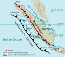
The Great Sumatran fault (a strike-slip fault), and the Sunda megathrust (a subduction zone), run the entire length of the island along its west coast. On 26 December 2004, the western coast and islands of Sumatra, particularly Aceh province, were struck by a tsunami following the Indian Ocean earthquake. More than 170,000 Indonesians were killed, primarily in Aceh. Other recent earthquakes to strike Sumatra include the 2005 Sumatra Earthquake and the October 2010 Sumatra earthquake.
Administration
 The ten administrative Provinces (provinsi) of Sumatra - including the smaller islands nearby - are listed below with their populations at the 2000 and 2010 Censuses,:[12] Note some 4 million of these residents of Sumatra do not live on the island itself—but on nearby islands administered collectively as "Sumatra". The final two of the provinces below do not have territory on the actual island.Traditional house in Nias North Sumatra
Name Area (km2) Population
Census 2000Population
Census 2010Population
Estimate 2014Capital Aceh 157,956.00 4,073,006 4,486,570 4,731,705 Banda Aceh North Sumatra
(Sumatera Utara)72,981.23 11,642,488 12,326,678 13,527,937 Medan West Sumatra
(Sumatera Barat)42,012.89 4,248,515 4,845,998 5,098,790 Padang Riau 87,023.66 3,907,763 5,543,031 6,359,790 Pekanbaru Jambi 50,058.16 2,407,166 3,088,618 3,412,459 Jambi South Sumatra
(Sumatera Selatan)91,592.43 6,210,800 7,446,401 7,996,535 Palembang Bengkulu 19,919.33 1,455,500 1,713,393 1,828,291 Bengkulu Lampung 34,623.80 6,730,751 7,596,115 7,972,246 Bandar Lampung Bangka-Belitung
(Kepulauan Bangka Belitung)16,424.14 899,968 1,223,048 1,380,762 Pangkal Pinang Riau Islands
(Kepulauan Riau)8,256.10 1,040,207 1,685,698 2,031,895 Tanjung Pinang Totals 480,847.74 42,616,164 50,613,947 54,339,256 Geography
 The longest axis of the island runs approximately 1,790 km (1,110 mi) northwest–southeast, crossing the equator near the centre. At its widest point, the island spans 435 km (270 mi). The interior of the island is dominated by two geographical regions: the Barisan Mountains in the west and swampy plains in the east. Sumatra is the closest Indonesian island to mainland Asia.Map of geological formation of Sumatra island
To the southeast is Java, separated by the Sunda Strait. To the north is the Malay Peninsula (located on the Asian mainland), separated by the Strait of Malacca. To the east is Borneo, across the Karimata Strait. West of the island is the Indian Ocean.
The backbone of the island is the Barisan Mountain chain, with the active volcano Mount Kerinci as the highest point at 3,805 m (12,467 ft), located at about the midpoint of the range. The volcanic activity of this region endowed the region with fertile land and beautiful sceneries, for instance around Lake Toba. It also contains deposits of coal and gold. The volcanic activity stems from Sumatra's location on the Pacific Ring of Fire—which is also the reason why Sumatra has had some of the most powerful earthquakes ever recorded: in 1797, 1833, 1861, 2004, 2005, and 2007.
 To the east, big rivers carry silt from the mountains, forming the vast lowland interspersed by swamps. Even if mostly unsuitable for farming, the area is currently of great economic importance for Indonesia. It produces oil from both above and below the soil – palm oil and petroleum.Mount Sinabung, North Sumatra
Sumatra is the largest producer of Indonesian coffee. Small-holders grow Arabica coffee (Coffea arabica) in the highlands, while Robusta (Coffea canephora) is found in the lowlands. Arabica coffee from the regions of Gayo, Lintong and Sidikilang is typically processed using the Giling Basah (wet hulling) technique, which gives it a heavy body and low acidity.[13]
Most of Sumatra used to be covered by tropical rainforest, but economic development coupled with corruption and illegal logging has severely threatened its existence. Even designated conservation areas have not been spared from this destruction.
The island is the world's fifth highest island, and the third highest in the Indonesian archipelago.
Batang Hari River is the longest river in the island with its source in the Minangkabau Highlands, stretching around 800 kilometres eastward to its estuary in the Jambi lowlands.
Largest cities
 Medan, the largest city in Sumatra
 Palembang, the second largest city in Sumatra
 The largest cities in Sumatra by population, listed by their 2010 census populations,[12] are:Batam, the third largest city in Sumatra
Rank Capital City province Population
2010 CensusCity Birthday Area in
Km 21 Medan North Sumatra 2,109,339 1 July 1590 265.10 2 Palembang South Sumatra 1,452,840 17 June 683 374.03 3 Batam Riau Islands 1,153,860 18 December 1829 715.0 4 Pekanbaru Riau 903,902 23 June 1784 633.01 5 Bandar Lampung Lampung 879,851 17 June 1682 118.50 6 Padang West Sumatra 833,584 7 August 1669 694.96 7 Jambi Jambi 529,118 17 May 1946 205.00 8 Bengkulu Bengkulu 300,359 18 March 1719 144.52 9 Dumai Riau 254,332 20 April 1999 2,039.35 10 Binjai North Sumatra 246,010 90.24 11 Pematang Siantar North Sumatra 234,885 24 April 1871 60.52 12 Banda Aceh Aceh 224,209 22 April 1205 61.36 13 Lubuklinggau South Sumatra 201,217 17 August 2001 419.80 Flora and fauna

 See also: List of national parks of IndonesiaSumatra supports a wide range of vegetation types which are home to a rich variety of species, including 17 endemic genera of plants.[14] Unique species include the Sumatran Pine which dominates the Sumatran tropical pine forests of the higher mountainsides in the north of the island and rainforest plants such as Rafflesia arnoldii (the world's largest individual flower), and the Titan Arum (the world's largest unbranched inflorescence).
The island is home to 201 mammal species and 580 bird species, such as the Sumatran Ground-Cuckoo. There are 9 endemic mammal species on mainland Sumatra and 14 more endemic to the nearby Mentawai Islands.[14] There are about 300 freshwater fish species in Sumatra.[15]
The Sumatran Tiger, Sumatran Rhinoceros, Sumatran Elephant, Sumatran Ground-Cuckoo, and Sumatran Orangutan are all Critically Endangered, indicating the highest level of threat to their survival. In October 2008, the Indonesian government announced a plan to protect Sumatra's remaining forests.[16]
The island includes more than 10 national parks, including 3 which are listed as the Tropical Rainforest Heritage of Sumatra World Heritage Site – Gunung Leuser National Park, Kerinci Seblat National Park and Bukit Barisan Selatan National Park. The Berbak National Park is one of three national parks in Indonesia listed as a wetland of international importance under the Ramsar Convention.
Demographics
 Sumatra is not particularly densely populated, with just over 100 people per km2 – more than 50 million people in total. Because of its great extent, it is nonetheless the fourth[17] most populous island in the world. The most populous regions include most of North Sumatra and central highlands in West Sumatra, while the major urban centers are Medan and Palembang.Minangkabau women carrying platters of food to a ceremony
Ethnic Groups
The people of Sumatra is multi-lingual, multi-diverse, and multi-religious. There are over 52 languages spoken, all of them belong to Austronesian language family (except Chinese and Indians). Most of these groups share many similar traditions, and the different tongues are closely related. Ethnic Malays dominate most of the eastern coast in the provinces of Riau, Bangka-Belitung, South Sumatra, Riau Islands, northern parts of Lampung and Bengkulu and in the easternmost parts of North Sumatra and Aceh, while people in the southern and central interior speak languages related to Malay, such as Lembak (that speak Col language), Kerinci (that speak Kerinci language) and Minangkabau people (that speak Minangkabau). The highlands of northern Sumatra is inhabited by the Bataknese, the northernmost coast is dominated by the Acehnese, while southernmost coast is dominated by Ethnic Javanese. Chinese and Tamil minorities are present in urban centres.
Languages
All Languages of Sumatra belongs to Nuclear Malayo-Polynesian sub-branch of Malayo-Polynesian in which in turn a branch of Austronesian language family. Within Nuclear Malayo-Polynesian, they were divided into several sub-branches that is Chamic (represent by Acehnese in which its closest relatives are languages spoken by Ethnic Chams in Cambodia and Vietnam), Malayic (Malay, Minangkabau and other closely related languages), Northwest Sumatran (Batak languages, Gayo and others), Lampungic (includes Proper Lampung and Komering) and Bornean (represented by Rejang in which its closest linguistic relatives are Bukar Sadong and Land Dayak spoken in West Kalimantan and Sarawak (Malaysia)). Northwest Sumatran and Lampungic branches are endemic to the island. Like all parts of Indonesia, Indonesian (which was based on Riau Malay) is the official language and the main Lingua franca. Although Sumatra has its own local Lingua franca, variants of Malay like Medan Malay and Palembang Malay are popular in North and South Sumatra, especially in urban areas. Minangkabau (Padang dialect) is popular in West Sumatra, some parts of North Sumatra, Bengkulu, Jambi and Riau (especially in Pekanbaru and areas bordered with West Sumatra). While Acehnese are also use as an inter-ethnic communication in some parts of Aceh province.
Religion
A majority of people in Sumatra are Muslims (87%), while 10% are Christians, 2% are Buddhist and 1% are Hindu.[18] Most central Bataks are Protestant Christians, a religion introduced by the German Rhenish Missionary Society.
Rail transport
Several unconnected railway networks built during Netherlands East Indies exist in Sumatra, such as the ones connecting Banda Aceh-Lhokseumawe-Besitang-Medan-Tebingtinggi-Pematang Siantar-Rantau Prapat in Northern Sumatra (the Banda Aceh-Besitang section was closed in 1971, but is currently being rebuilt).[19] Padang-Solok-Bukittinggi in West Sumatra, and Bandar Lampung-Palembang-Lahat-Lubuk Linggau in Southern Sumatra.
See also
References
- http://edition.cnn.com/2013/06/19/world/asia/singapore-haze/?hpt=hp_t3
- Drakard, Jane (1999). A Kingdom of Words: Language and Power in Sumatra. Oxford University Press. ISBN 983-56-0035-X.
- Munoz. Early Kingdoms. p. 175.
- Sneddon, James N. (2003). The Indonesian language: its history and role in modern society. UNSW Press. p. 65. ISBN 9780868405988.
- Macdonell, Arthur Anthony (1924). A practical Sanskrit dictionary with transliteration, accentuation, and etymological analysis. Motilal Banarsidass Publ. p. 347. ISBN 9788120820005.
- Reid, Anthony (2005). An Indonesian Frontier: Acehnese and Other Histories of Sumatra. National University of Singapore Press. ISBN 9971-69-298-8.
- http://www.bps.go.id/tab_sub/view.php?kat=1&tabel=1&daftar=1&id_subyek=12¬ab=1
- Coedès, George (1968). Walter F. Vella, ed. The Indianized States of Southeast Asia. trans.Susan Brown Cowing. University of Hawaii Press. ISBN 978-0-8248-0368-1.


Tiada ulasan:
Catat Ulasan